- Home
- Destination
- Places to Visit
- Activities
- Cultural Tours
- Festival Tours
- Thimphu Tshechu
- Paro Tshechu
- Punakha Tshechu and Drubchen
- Takin Festival
- The Black-necked Crane Festival
- Chorten Kora Festival
- Dochula Druk Wangyel Festival
- Gomphu Kora Festival
- Haa Summer Festival
- Jambay Lhakhang Festival
- Kurjey Festival
- Lhuntse Tshechu
- Matsutake Festival
- Merak Tshechu
- Mongar Tshechu
- Nimalung Festival
- Nomad Festival
- Pema Gatshel Tshechu
- Sakteng Festival
- The Gasa Tshachu
- Trashigang Tshechu
- Adventure Tour
- Trekking Tours
- Druk Path Trek
- Dagala Thousand Lakes Trek
- Bumthang Cultural Trek
- Bumthang Owl Trek
- Gangtey Trek
- Punakha Winter Trek
- Snowman Trek I
- Snowman Trek II
- Wangduephodrang Tshechu
- Wild East Rodung La Trek
- Duer Hot Springs Trek
- Jomolhari Loop Trek
- Jomolhari Trek
- Laya Gasa Trek
- Merak Sakteng Trek
- Nabji Korphu Trek
- Samtengang Winter Trek
- Trongsa Tshechu
- Ura Yakchoe
- Spirituality & Wellness
- About Bhutan
- Travel Information
- Hotels
- Inquiry
- Gallery
- About Us
Laya Gasa Trek

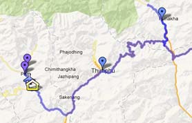
The Laya-Gasa Trek is considered one of the most scenic treks in Bhutan, offering amazing views of some of the most pristine and unspoiled landscapes in Bhutan. This fourteen day, 217 km journey begins at Drukgyel in Paro and takes you through gorgeous alpine meadows, high mountain passes and dense sub-tropical jungles before terminating in Damji in Tashithang.
The first five days of this trek follow the same route as the Jomolhari Trek I through Jigme Singye National Park and offer awe-inspiring views of Mt. Jomolhari, Jichu Drake and Tsherimgang. On the sixth day the path diverges and you will depart Lingshi for the camp site at Chebisa, a charming little village adorned with a beautiful waterfall of crystal clear water.
Along the trail you’ll be able to spot indigenous animals such as blue sheep and Takins, the national animal of Bhutan. You’ll travel through remote mountain villages inhabited by Layaps (people of Laya), a distinct segment of the Bhutanese society with unique culture, traditions and appearance. Thhe trek also offers a day of relaxation at the famous Gasa hot springs that is sure to rejuvenate you.
This is one of the more difficult treks offered in Bhutan due to the high altitudes and steep ascents and descents along the path. The best seasons to complete this challenge are in April-June and Mid-September-Mid-November.
Day 1: Gunitsawa Village – Sharna Zampa
40mins, 80 m descent, camp altitude 2,850 m. This trek begins at Gunitsawa Village were you pass the army post. At the army checkpost your trek permit (provided by your tour operator) will be checked and endorsed. The campsite is on the opposite side of the river, not far from Gunitsawa.
Day 2: Sharna Zampa – Thangthangkha
Distance 22 km, 7-8 hours, 770 m ascent, 10 m descent, camp altitude 3,610 m. On this long day, the trail continues with lots of small ups and downs. After going uphill through the river valley the valley finally narrows gradually to a mere path which descends to a meadow where a camp will b…
Day 3: Thangthangkha – Jangothang
Distance 19 km, 5-6 hours, 480 m ascent, camp altitude 4,080 m. If you did not see Mt. Jomolhari the previous evening, you will still have a chance to get a great view early this morning. This morning the trek continues up the Paro Chhu valley which widens into patches of alpine meadow and sc…
Day 4: Jangothang Halt
The rest day in Jangothang provides plenty of possibilities for day hikes with great views of lakes and snow capped mountains such as Jomolhari and Jichu Drake. There are good chances to spot some blue sheep on the upper slopes of the valley. Jangothang is a perfect environment for your acclimati…
Day 5: Jangothang – Lingshi
Distance 18 km, 6-7 hours, 840 m ascent, 870 m descent, camp altitude 4,010 m. This is one of the longest days of the trek. A short distance from the camp the trail begins climbing rapidly for about half an hour and then becomes a gradual ascent to the Nyilila pass at 4,870m. While on the cl…
Day 6: Lingshi – Chebisa
Distance 10 km, 5-6 hours, 280 m ascent, 410 m descent, camp altitude 3,880 m. Today is the shortest walking day, and you can really take it easy. Shortly after starting you will reach a chorten below Lingshi Dzong. Here, you have the choice of staying on the main trail or taking a detour up …
Day 7: Chebisa – Shomuthang
Distance 17 km, 6-7 hours, 890 m ascent, 540 m descent, camp altitude 4,220 m. The morning starts with a long ascent behind Chebisa Village (2-3 hours) through a wide pastureland towards Gobu La (pass). On the way, you will see a few people herding yaks. There is also a great chance to spot l…
Day 8: Shomuthang – Robluthang
Distance 18 km, 6-7 hours, 700 m ascent, 760 m descent, camp altitude 4,160 m. You begin by climbing up the valley to view Kang Bum (6,526 m) and some edelweiss. After two hours of climbing you will reach Jhari La (4,750m), from where you catch the first glimpse of Sinche La, the pass you wil…
Day 9: Robluthang – Limithang
Distance 19 km, 6-7 hours, 850 m ascent, 870 m descent, camp altitude 4,140 m. The trek starts out with an initial 40-60mins ascent before gradually raising for another 1.5 hours through a boulder field. It is then a 1 hour steep ascent before reaching Sinche La (5,005m) – the final and high…
Day 10: Limithang – Laya
Distance 10 km, 4-5 hours, 60 m ascent, 340 m descent, camp altitude 3,840 m. Today, you walk downhill all the way along a narrow, winding river valley. After a long time, the trail takes you through densely forested region. The trail leads you to the west side of Laya village. From the west …
Day 11: Laya – Koina
Distance 19 km, 6-7 hours, 260 m ascent, 1,070 m descent, camp altitude 3,050 m. The trail winds up and down along the river valley of Mo Chhu avoiding natural obstacles and affording breath-taking views of the raging river, feeder streams and waterfalls. Lots of ups and downs will lead you t…
Day 12: Koina – Gasa
Distance 14 km, 6-7 hours, 740 m ascent, 1,500 m descent, camp altitude 2,240 m. Today you will have the last major climb of the Laya Gasa Trek. You will cross Bari La (3,740m), after which the trail descends all the way until you reach Gasa village (2,770m), where you will find the first res…
Laya Gasa Trek – Finish
This trek finishs in Gasa, this remote village is home to a distinctive and architecturally unique Dzong.
Accommodations and facilities:
- There are limited choices of accommodations in Bhutan. With a few exceptions of highly over priced international chain properties, hotels in Bhutan are small with 15 to 20 rooms. The hotels have been categorized by local authorities as Star 1, 2 and 3, with 3 Star being on the top level 1Star at the bottom and naturally we have pick the 3 Star category hotels and resorts which are local architecture with Bhutanese décor, well maintained and staffed with the friendly locals. There is disparity in the rooms in most of the hotels and travelers of the same group may end up in two different types of rooms although you have paid the same amount. You will have private bathroom with 24 hour running cold and hot water. They provide some fundamental toiletry supplies but hair dryers, iron and ironing board etc may not be available.
- Hotels in Paro and Thimphu do have internet access in office or reception areas. There are some new deluxe properties and international chain resorts which are above the traditional classification criteria and in the higher side in terms of price and can be booked with supplemental cost. Hotel listed on the itinerary are suggestions only and during peak season and tours timed with festival, we may not get the same hotels and in that case, we will book you in the similar property or upgrade you to the higher level.
Guide and Escorts
- Our Tour Guides are local individuals with college degree, government certification, experienced and with knowledge on the destination, history, culture and religion and most importantly they are easy going, detailed oriented, patient and high level of customer service skills. They will uncover the wonders of the destinations for you which you would never find on your own. They ensure that everything goes well with your tour without a hitch.
Vehicle:
- We use good condition Toyota SUV and Toyota Coaches for all transfers and tours. Driver and guide is not the same person. Driver may speak little or no English but they know the road and are skillful to fix the problem in case of mechanical breakdowns. Depending on group size, we will use Japanese made Sedan cars, SUVs or minivan for entire transfers and tours.
International and Internal Flights:
- All internal flights are part of travel plan and are locally booked by us. You will be emailed e-ticket receipts once the reservation is booked and tickets issued. But you have liberty to book your international airfare on your own. We can certainly help you book international flight if that originates from the city that you live in. Once you receive itinerary, it's your responsibility to verify the itinerary and reconfirm the schedules.
Visa and Permits:
- Passport should be valid for 6 months or more at the time of travel. We will take care of Bhutan Visa and permits. Bhutan Visa Fees of USD 20 which will be collected with the Tour Payment in advance. You will need to provide a copy of your passport which should be sent to us by email for Bhutan Visa Processing. Bhutan visa is preprocessed by us and we will provide you a copy the Visa Approval Letter before your trip which you will need to present at Druk Air counter at the time you check in for flight to Bhutan. You will get actual visa seal on your passport upon arrival at Paro airport.
Trip Activity Level:
- This trip is basically motor vehicle based sightseeing with some short hikes and village visits and suitable for all travelers with regular health conditions. When we are driving from one city to another, we will be driving from 3-6 hours with occasional stops for photography and for refreshments. Roads are narrow and some portions may be rough and damaged. The itinerary allows enough acclimatization for you and it's advisable that you should keep physically fit and start mild exercises like jogging, swimming, cycling or practice some aerobics about 2-3 months ahead of the trip. It's your responsibility to determine that you are fit for this trip and if you have any health conditions, please consult with your physician before you sign up for this trip.
Note on Itinerary:
- We do our best to adhere to the itinerary but it should be taken as a generic guideline in terms of what you expect to do or see during the tour and may differ in the practical ground from exact sequence or order of the sights to the overnight places depending on the local conditions.
Booking:
- When you are sure you are traveling, please don't delay in booking so that we can confirm you in preferred hotels and flights. A 100% of both the Tour and Airfare is requested along with a completed trip application form plus copy of the photo page of your passport.
Cancellation:
- 100% Refund if tour canceled within 60 Days from the start of the tour.
- 50% Refund if tour canceled within 45 Days from the start of the tour.
- 25% Refund if tour canceled within 30 Days from the start of the tour.
- No Refund if tour canceled less than 30 Days from the start of the tour.
Final Trip Dossier:
- A final trip dossier with local contacts, hotel lists, check lists, travel notes and relevant information will be sent about a month ahead of the trip.
Tour Cost:
What's Included
- Bhutan Royalty ($65 per person per day).
- Visa Fees ($40 per person).
- All necessary permit fees.
- All transfers and sightseeing with entrance fees.
- All meals including evening tea.
- All accommodation in our partner hotels, which are some of the best in the country on twin sharing basis.
- All trekking equipments and logistics including cooks, camp personnel, horsemen and ponies.
- English-speaking tour leader, guide and driver.
- Trekking Insurance (Our value-added service).
- Cultural Performance (our value-added service).
- Airfare for flights into and out of Bhutan.
- All personal expenses like laundry, telephone, tips, shopping expenses.
- Meals and Beverages other than the ones mentioned above (see inclusions).
- Spa Charges.
- Travel and Medical insurance.
Tour Facts
| Length | : | |
| Start | : | Paro |
| Finish | : | Paro |
| Trip Style | : | Trekking Tour |
| Discounts | : | Applicable on this trip |
| Group Size | : | Maximum 12, Avg 5 |
| Group Leader | : | Certified Tour Leader from The DQA |
| Transport | : | New Model Toyota Hiace /Coaster bus/Land Cruiser not more than 3 years old |
| Trip Rating by Popularity | ||
| : |  |
|
| Physical Demand Rating | ||
| : |  |
|
| Can it be Customized? | ||
| : | Yes | |
Tour Map